onDraw
would be faster if we created the
Path
once and for all in the constructor of the
ManhattanView.
The
Path
would be a field of the
ManhattanView.
arrays.xml.Manhattan/res/values.
New → Values resource file
File name: arrays.xml
OK
Put the following content into the file. Each string contains one comma separating the longitude from the latitude.
<?xml version="1.0" encoding="utf-8"?>

<resources>
	<string-array name="points">
		<item>-73.971548f,	40.72921f</item>	<!-- East River at East 17th Street -->
		<item>-73.974595f,	40.735519f</item>	<!-- 24 -->
		<item>-73.971806f,	40.742998f</item>	<!-- 34 -->
		<item>-73.96215f,	40.754767f</item>	<!-- 53 -->
		<item>-73.954296f,	40.762146f</item>	<!-- 65 -->
		<item>-73.946185f,	40.771474f</item>	<!-- 81 -->
		<item>-73.942022f,	40.776154f</item>	<!-- 89 -->
		<item>-73.942022f,	40.776154f</item>	<!-- 96 -->
		<item>-73.93816f,	40.787008f</item>	<!-- 103 -->
		<item>-73.929534f,	40.795326f</item>	<!-- 118 -->
		<item>-73.929062f,	40.800946f</item>	<!-- 125 -->
		<item>-73.934212f,	40.808775f</item>	<!-- Harlem River at 132nd Street -->
		<item>-73.933868f,	40.817772f</item>	<!-- 143 -->
		<item>-73.935113f,	40.83547f</item>	<!-- 163 -->
		<item>-73.922195f,	40.855857f</item>	<!-- Dyckman Street -->
		<item>-73.91078f,	40.869878f</item>	<!-- 218 -->
		<item>-73.911767f,	40.873416f</item>	<!-- Broadway Bridge -->
		<item>-73.922968f,	40.877018f</item>	<!-- Henry Hudson Parkway Bridge -->
		<item>-73.926916f,	40.877082f</item>	<!-- Hudson River -->
		<item>-73.933096f,	40.867379f</item>	<!-- Riverside Drive -->
		<item>-73.943224f,	40.852417f</item>	<!-- Hudson River at West 181st Street -->
		<item>-73.946786f,	40.850339f</item>	<!-- George Washington Bridge -->
		<item>-73.946786f,	40.850339f</item>	<!-- 168 -->
		<item>-73.95052f,	40.834626f</item>	<!-- 155 -->
		<item>-73.955026f,	40.827417f</item>	<!-- 144 sewage treatment plant -->
		<item>-73.956399f,	40.828034f</item>	<!-- 144 -->
		<item>-73.959446f,	40.82365f</item>	<!-- 137 -->
		<item>-73.957601f,	40.822676f</item>	<!-- 137 -->
		<item>-73.994765f,	40.771669f</item>	<!-- 57 -->
		<item>-73.995152f,	40.769524f</item>	<!-- 54 -->
		<item>-73.999872f,	40.763316f</item>	<!-- 44 -->
		<item>-74.001718f,	40.762276f</item>	<!-- 42 -->
		<item>-74.007726f,	40.754052f</item>	<!-- 29 -->
		<item>-74.009442f,	40.749825f</item>	<!-- 23 -->
		<item>-74.00794f,	40.748362f</item>	<!-- 21 -->
		<item>-74.009228f,	40.740754f</item>	<!-- Meatpacking District -->
		<item>-74.010344f,	40.739258f</item>	<!-- Gansevoort Street -->
		<item>-74.011545f,	40.726218f</item>	<!-- Holland Tunnel -->
		<item>-74.013176f,	40.718315f</item>	<!-- Battery Park City -->
		<item>-74.016609f,	40.718737f</item>	<!-- Battery Park City -->
		<item>-74.019227f,	40.706539f</item>	<!-- South Cove -->
		<item>-74.014893f,	40.70078f</item>	<!-- Battery Park -->
		<item>-74.009314f,	40.701919f</item>	<!-- Heliport -->
		<item>-73.997984f,	40.708523f</item>	<!-- north of Brooklyn Bridge -->
		<item>-73.977985f,	40.710475f</item>	<!-- Corlears Hook Park -->
		<item>-73.976011f,	40.712752f</item>	<!-- Grand Street -->
		<item>-73.972964f,	40.720819f</item>	<!-- East 6th Street -->
	</string-array>
</resources>
Copy the array of strings into the
Path.
You’ll have to rename the
latitude
variable because
onDraw
already contains a variable with this name.
		Resources resources = getResources();
		String[] points = resources.getStringArray(R.array.points);
		Path path = new Path();

		for (int i = 0; i < points.length; ++i) {
			int comma = points[i].indexOf(",");

			//everything before the comma
			float longitude = Float.valueOf(points[i].substring(0, comma));

			//everything after the comma
			float latitude = Float.valueOf(points[i].substring(comma + 1));

			if (i == 0) {
				path.moveTo(longitude, latitude);
			} else {
				path.lineTo(longitude, latitude);
			}
		}
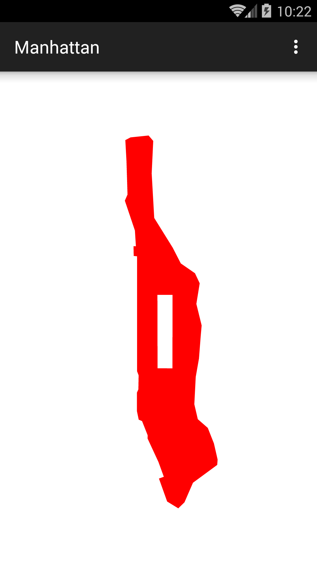
WHITE
rectangle after you draw Manhattan.
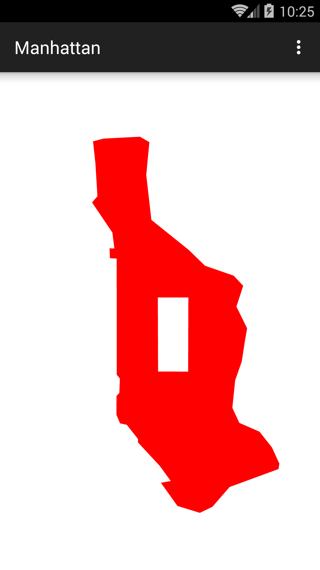
	Path park = new Path();
	park.moveTo(-73.97305f, 40.764291f);	//Grand Army Plaza
	park.lineTo(-73.981762f, 40.767997f);	//Columbus Circle
	park.lineTo(-73.958116f, 40.800556f);	//Frederick Douglass Circle
	park.lineTo(-73.949235f, 40.796848f);	//Frawley Circle

	park.close();
	canvas.drawPath(park, paint);
What about the lakes in Central Park?
scale.
Surprisingly, the rotation is specified in degrees, not radians.
canvas.rotate(-28.9f); //degrees; negative for counterclockwise
rotate.
canvas.scale(2.0f, 1.0f);
onDraw.
You will have to import
android.graphics.Matrixandroid.util.Log.Log.d//Canvas.getMatrix is deprecated, but View.getMatrix doesn't show the //transformations we applied to the Canvas. Matrix matrix = canvas.getMatrix(); float[] values = new float[9]; //Create an empty array. matrix.getValues(values); //Fill up the array. Log.d("myTag", values[0] + "\t" + values[3] + "\t" + values[6]); Log.d("myTag", values[1] + "\t" + values[4] + "\t" + values[7]); Log.d("myTag", values[2] + "\t" + values[5] + "\t" + values[8]);
-
At the start of
onDraw, we got a perfect identity matrix:03-08 10:44:07.420 3656-3656/edu.nyu.scps.manhattan D/myTag: 1.0 0.0 1.0 03-08 10:44:07.420 3656-3656/edu.nyu.scps.manhattan D/myTag: 0.0 1.0 0.0 03-08 10:44:07.420 3656-3656/edu.nyu.scps.manhattan D/myTag: 0.0 0.0 1.0
-
After the first
canvas.translateon a Samsung Galaxy S5 in portrait orientation, the matrix is03-08 10:56:15.983 3760-3760/edu.nyu.scps.manhattan D/myTag: 1.0 0.0 0.0 03-08 10:56:15.983 3760-3760/edu.nyu.scps.manhattan D/myTag: 0.0 1.0 0.0 03-08 10:56:15.983 3760-3760/edu.nyu.scps.manhattan D/myTag: 540.0 838.0 1.0
With the status and action bars visible, theManhattanViewis 1080 × 1677; see Japan. When we try to draw a point at(x, y), the point actually appears at screen coördinates(x′, y′), where x′ = 1x + 540
y′ = 1y + 838 -
After the
canvas.scale, the matrix is03-08 11:09:24.745 3862-3862/edu.nyu.scps.manhattan D/myTag: 5078.688 0.0 0.0 03-08 11:09:24.745 3862-3862/edu.nyu.scps.manhattan D/myTag: -0.0 -6708.0 -0.0 03-08 11:09:24.749 3862-3862/edu.nyu.scps.manhattan D/myTag: 540.0 838.0 1.0
When we try to draw a point at(x, y), the point actually appears at coördinates(x′, y′), where x′ = 5078.688x + 540
y′ = –6708y + 838 -
After the second
canvas.translate, the matrix is03-08 11:13:56.166 3933-3933/edu.nyu.scps.manhattan D/myTag: 5078.688 0.0 0.0 03-08 11:13:56.166 3933-3933/edu.nyu.scps.manhattan D/myTag: -0.0 -6708.0 -0.0 03-08 11:13:56.166 3933-3933/edu.nyu.scps.manhattan D/myTag: 376185.13 274457.3 1.0
When we try to draw a point at(x, y), the point actually appears at coördinates(x′, y′), where x′ = 5078.688x + 376185.13
y′ = –6708y + 274457.3 For example, the point at the East River and 17th Street hasx = –73.971548 (the longitude) andy = 40.72921 (the latitude). The above formulæ yieldx′ = 507 (the column) andy′ = 1246 (the row) when rounded to the nearest integer. This is a very modest pair of screen coördinates after all those huge numbers.